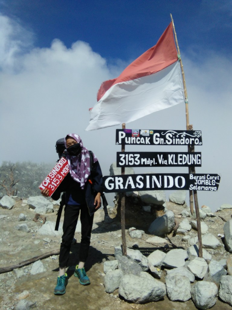
Mount Sindoro, or often also called Mount Sundoro, has an altitude of 3,153 meters above sea level.
This mountain is located around Temanggung and Wonosobo Regencies, Central Java.
Mount Sindoro is an active volcano characterized by the Strato cone type, and it last erupted once in 1971.
The hiking trail via Kledung is a commonly used route, located in the village of Kledung. To go to the Sindoro mountain climbing base camp via Kledung, you can take a bus heading for Magelang – Wonosobo, and get off at the village of Kledung
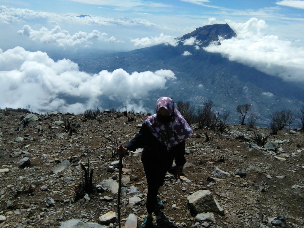
It is located next to his twin brother, Mount Sumbing. Mount Sindoro is unique from other mountain peaks, which has a very large peak more than several times the size of a football stadium.
Trail and Travel Time of Mount Sindoro Climbing via Kledung
Hiking Route Elevation Travel Time
Basecamp – Pos 1 ± 1900 masl (Pos 1) ± 20 – 30 minutes
Pos 1 – Pos 2 ± 1980 masl (Pos 2) ± 1 – 1.5 hours
Pos 2 – Pos 3 ± 2350 masl (Pos 3) ± 2 – 3 hours
Pos 3 – Sunrise Camp ± 2423 masl (Sunrise Camp) ± 20 – 40 minutes
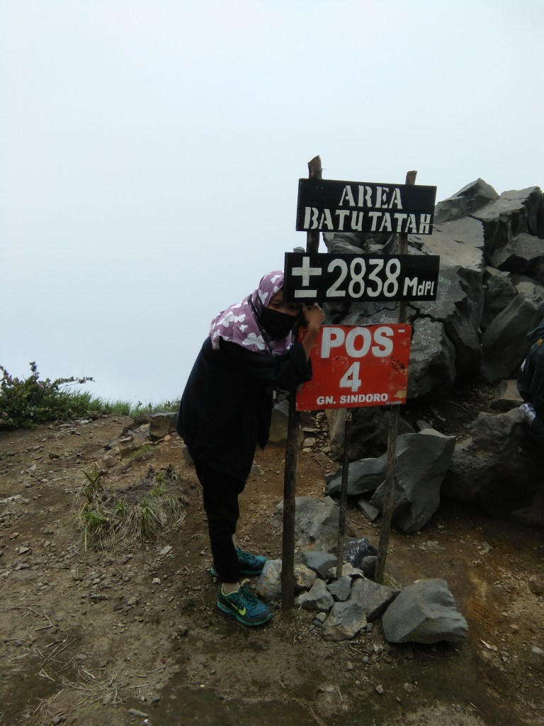
Sunrise Camp – Pos 4 ± 2838 masl (Pos 3) ± 1-2 hours
Pos 4 – Puncak Mount Sindoro 3153 masl (Puncak Sindoro) ± 1-2 hours
The Sindoro mountain climbing route to heading 1 is in the form of a cobblestone road that passes through the residents’ agricultural land. There are already many motorcycle taxi services available to go to post 1, but if you choose to walk, then you need about 45 minutes to 1 hour. After crossing the boundaries of agricultural land the population will reach Watu Gede at an altitude of 1,900 masl.
The journey continues with a sloping road in the form of solid land which will eventually climb up, but still not too heavy. About 2 hours will arrive at post 2 at an altitude of 2,120 meters above sea level.
Next trip to Pos 3 which is the last post in the form of an uphill track in the form of solid soil mixed with rocks, approaching post 3, the track is increasingly uphill with large rock tracks. About 3 hours will arrive at post 3 with an altitude of 2,530 masl. Here the climbers usually build tents to continue the summit tomorrow.
After passing through a long forest of Lamtoro, you will arrive at post 4, Batu Tatah.
Padang edelweis will be a beautiful view bonus that will be welcomed before reaching the summit. The summit of Mount Sindoro is the plain on the crater rim. On the east there are two twin craters covering an area of 210 x 150 meters and bounded by a crater wall that surrounds them. Climbers can also walk around the crater wall of Mount Sindoro.
Sindoro indeed makes thirsty seekers beautiful scenery moments. However, there are certainly many struggles to tread, because of the steep road, slippery terrain, and the lack of water sources here. It takes a little extra preparation to conquer this mountain, like the other SS (Sumbing and Slamet). And you should not go up the mountain on the red holiday date, because a crowd that is too will only make you inconvenience later.
